Alişar Höyük: A Layered Cake of Millennia in the Heart of Anatolia
Alişar Höyük (Turkish: Alişar Höyük) is one of the most impressive mounds in Central Anatolia and a veritable archive of human history compressed into a thirty-meter-high hill. Here, 45 kilometers southeast of the city of Yozgat, north of the modern village of Alişar in the Sorgun district, layer upon layer lie the traces of the Neolithic, Chalcolithic, Early Bronze Age, Assyrian merchants, the Hittite Kingdom, the Phrygians, and the late Byzantines. For archaeologists, Alishar-Huyuk is a key reference point for the chronology of all of Anatolia; for the traveler, it is a place where eight millennia of continuous life literally lie beneath one’s feet.
History and Origins of Alishar-Huyuk
The first people settled here as far back as the Neolithic era, and the conditions were, to put it mildly, unusual: the settlement stood in the middle of a lake, and the hill itself was the only land suitable for habitation. Archaeologists found traces of this earliest layer 26 meters below the hill’s modern surface and approximately 11 meters above the mainland’s “virgin” soil. With the onset of the Chalcolithic period, the water began to recede, the surrounding lands dried up, and people gradually descended from the hill, but they did not forget about safety—the first external fortifications began to be erected around the settlement.
By the Early Bronze Age (approximately 3200–2600 BCE), Alishar already looked like a real city: rectangular houses with mud-brick walls and flat roofs, a massive defensive wall with gates, and a clear layout. Later, the inner and outer walls were reinforced, and the hill itself grew into the “capital” of the region. It was during the Middle Bronze Age, in the second millennium BCE, that Alishar-Huyuk entered the annals of major politics: it became a trading post in the Assyrian merchant network stretching between the Hittite city of Hattusa and the Cappadocian city of Kanesh (Kültepe).
This is evidenced by the 53 cuneiform tablets found here (including copies), written in the Old Assyrian language of the so-called “Cappadocian type.” This is a typical archive of an Assyrian trading post: contracts, receipts, and references to journeys. In some tablets, merchants describe their return from Zalpuwa (Zalpa); others mention Kanesh and Hattusa; and still others feature the merchant Amur-Assur, known from documents found in the karum at Kültepe. One tablet bears the eponym Adad-bani, dating to the final years of the reign of Shamshi-Adad I of Assyria (1808–1775 BCE). Two more tablets bear the seal of “Anitta the Prince,” which has given rise to a tempting hypothesis: that very same Anitta, king of Kushshar in the late 18th century BCE, who, according to his own boastful text, burned the city of “Kushshar,” could very well have destroyed Alishar as well.
After the Hittite conquest, the city came under the influence of the empire centered in Hattusa. From 1400 to 1200 BCE Alishar likely bore the name Ankwa—it is this city that is frequently mentioned in Hittite texts, and the mention of the place name Amkwa in local tablets makes identification almost inevitable. Its end came around 1200 BCE, when, along with the collapse of the Hittite Kingdom, Stratum IV was consumed by fire; for many centuries, the hill stood almost empty. The Phrygians came here later and left their cultural layer; followed by the Medes, Persians, Hellenistic rulers, Romans, and finally the Byzantines, who left the ruins of a late church on the hilltop.
Architecture and What to See
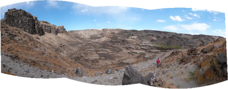
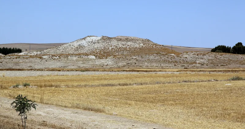
Alishar-Huyuk is neither the colonnade of an ancient temple nor a tourist-ready route with signs. It is a hill, and therein lies its main beauty: before you lies a complete geological record of human civilization, and one must know how to read it. The size of the tell is impressive in itself: 520 by 350 meters at the base and 30 meters high, making it one of the largest mounds in Anatolia.
The Citadel and Three “Blades”
At the top, the hill is crowned by a truncated cone—archaeologists designate it with the letter A; this is the ancient citadel. From it, like petals, three lower “lobes” extend outward—B, C, and D. To the east and south, a sprawling lower city adjoins the main hill. Over the centuries, the fortifications were rebuilt: the inner fortress was expanded, the outer wall gained new bastions, and during the Hittite period, massive gates with underground passages and towers along the perimeter appeared. Traces of these defensive lines are still clearly visible in the landscape today.
The oldest settlement of the Early Bronze Age
The early layers reveal a surprisingly restrained, almost ascetic architecture: rectangular mud-brick houses on stone foundations, flat roofs, and compacted clay floors. The dwellings were tightly packed together, forming what archaeologists call an “agglutinative” village layout. Later, the houses became larger, and the walls were plastered both inside and out—a sign of growing prosperity. It was also then that cultural exchange with Mesopotamia began.
An Assyrian trading post and a Hittite city
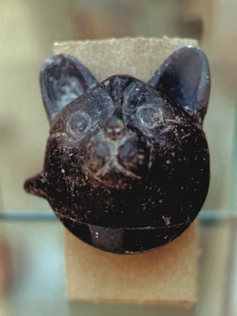
It was precisely in the Middle Bronze Age layer, during that very era of caravan trade, that cuneiform archives, Cappadocian-style pottery, and zoomorphic riton vessels—elegant jugs shaped like animal heads—dating to 1700–1500 BCE were found. During the Hittite period, apparently corresponding to the Ankova phase, the city was surrounded by a new wall, and public buildings were erected in the citadel. All of the most valuable finds—tablets, seals, rhytons, and pottery—are housed in the Museum of Anatolian Civilizations in Ankara, and, in fact, any serious visit to Alishar-Huyuk should begin there.
The Phrygian Layer and the Byzantine Church
After the catastrophe of 1200 BCE, the hill was gradually settled by the Phrygians. This layer reveals a blend of Hittite traditions and the new culture; the previously destroyed citadel was rebuilt atop the old foundations. A few dozen kilometers to the south lies Kerkene—a massive Iron Age Phrygian city—and together with Alishar, it forms a veritable “Phrygian hub” of Central Anatolia. At the very top of the hill, archaeologists have excavated the ruins of a small church from the Late Roman or Byzantine period—a quiet epilogue to eight thousand years of history.
Çadır Höyük Next Door
Twelve kilometers northwest of Alishar lies its most important neighbor—Çadır Höyük (Çadır Höyük)—which modern archaeologists tentatively identify with the Hittite city of Zipparanda. The “Alishar + Çadır” route is a classic choice for those who want to understand the landscape of the Hittite province. Excavations at Çadır are more active: while work at Alishar since 1992 has consisted mainly of topographic surveying and aerial photography using hot-air balloons, Ronald Gorny has launched a full-scale archaeological season at Çadır Höyük. This contrast is useful: Chadyr shows what a “living” site with active excavations looks like, while Alishar resembles an archive lying dormant beneath the turf, still awaiting its researchers.
Excavation Methods and Scale of Work
The University of Chicago expedition employed one of the most advanced methods of its time here: the entire area of the hill was divided into 10-by-10-meter squares, strictly oriented according to the cardinal directions. Each square was excavated layer by layer, with careful documentation of finds and stratigraphy. It was precisely thanks to this discipline that archaeologists were able to tie ceramic types, seals, and architectural horizons to absolute dates. In essence, the results of the 1927–1932 seasons set the standard for the chronology of Central Anatolia for many decades: when similar layers were found at Hattusa, Kanish-Kültepe, or Beysultana, they were compared specifically to the Alishar scale.
Interesting Facts and Legends
- During the Neolithic period, Alishar-Huyuk stood literally on an island: the settlement was surrounded by a lake, and only as the region dried up during the Chalcolithic period did people begin to settle on the adjacent shores.
- One of the tablets mentions the merchant Amur-Assur—the same name appears in the Karum archive at Kültepe; it is possible that this refers to the same person, whose trading network spanned Anatolia from Kanish to Hattusa.
- The seal of “Anitta the Prince” on two tablets gave rise to the hypothesis that the semi-legendary Hittite king Anitta burned Alishar: in his own texts, he boasted that he had taken the city of Kushshar and, “sowing weeds in its place,” cursed it for all time.
- The entire collection of unique finds—pottery, a riton shaped like an animal’s head, and figurines made of fired clay—is now on display at the Museum of Anatolian Civilizations in Ankara and is considered one of the finest Bronze Age collections in Turkey.
- The 1927–1932 excavations led by Hans Henning von der Osten and his deputy Erich Schmidt became one of the University of Chicago’s first large-scale archaeological expeditions in the Middle East and set the standard for stratigraphy across all of Anatolia.
How to get there
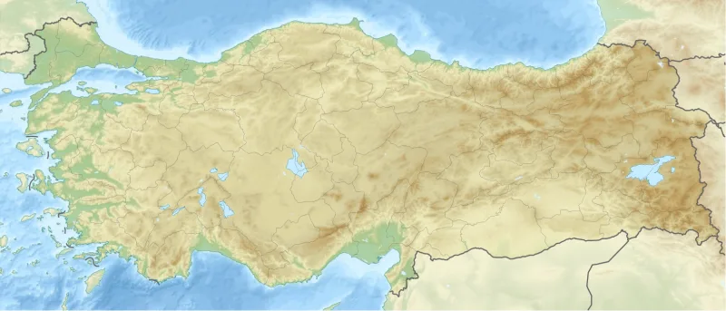
Alishar-Huyuk is located in the remote rural area of Yozgat Province, and the most convenient way to get there is by car. The nearest major airports are Ankara Esenboğa (ESB), approximately 220 kilometers to the west, and Kayseri (ASR), approximately 150 kilometers to the southeast. For Russian-speaking tourists, it is usually easier to fly via Istanbul with a connecting domestic flight.
The classic route is to rent a car at the airport and drive along Highway D200 (Ankara–Yozgat–Sivas). From Yozgat, head southeast toward the town of Sorgun, then turn toward the village of Alishar; the hill itself is located north of the village. From Ankara, the drive takes about 3.5–4 hours one way. Without a car, you can actually take a bus to Sorgun from the Ankara bus station (AŞTİ), and from there—by taxi or hitchhiking—about 25 kilometers to the village. There are few signs pointing to the hill itself, so it’s a good idea to save the GPS coordinates (39.606° N, 35.261° E) in your offline navigation app beforehand.
Tips for travelers
The best time to visit is spring (April–May) and early fall (September–October). In summer, the plateau gets scorching hot, and there is practically no shade on the hill; in winter, the steppe road can be difficult to navigate due to snow and mud. Allow about 90 minutes to explore the tell itself: you’ll need to climb the slope at a leisurely pace, explore the main citadel, walk around the “wings,” and descend from the lower town side.
Be sure to bring water, a hat, sunscreen, and comfortable shoes with sturdy tread—the hill’s surface is uneven and slippery in places after rain. There’s nowhere to eat on site, so it’s wise to stock up on food and a thermos in Yozgat or Sorgun. There is no visitor infrastructure here in the usual sense: no ticket office, no cafes, no souvenir shops—and this, too, is part of the site’s unique charm, reminding Russian travelers of the “wild” burial mounds of the Black Sea steppes.
To make the most of your time, it’s worth combining this trip with other sites in the region. In a single day, you can realistically visit Alishar-Huyuk, the neighboring tell of Çadyr-Huyuk, and the Phrygian city of Kerkene—resulting in a rich itinerary “in the footsteps of the Hittites and Phrygians.” Over two days, you can add Bogazkale-Hattusa, the former capital of the Hittite Kingdom, and Yazılıkaya, its famous rock sanctuary. And be sure to set aside half a day for the Museum of Anatolian Civilizations in Ankara: it is there that the very tablets, rhytons, and seals from Alishar-Huyuk are on display, and without them, a visit to the mound remains largely “silent.” Alishar-Huyuk is not a place for those chasing photogenic ruins, but for travelers ready to hear the whispers of the earth’s layers: that is its greatest value.